
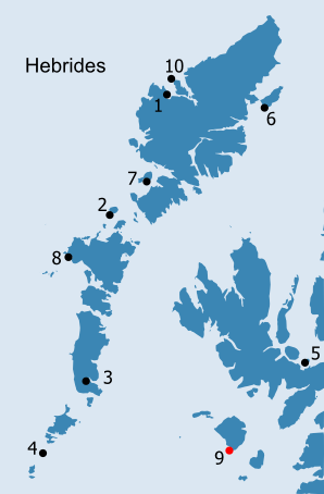
HEBRIDES: H9. Papadil (Small Isles, Rùm) · Introduction Loch Papadil centred NM 3643 9210 Papadil Lodge NM 36572 92224 Papadil on Rùm is isolated not only from the rest of the Western Isles, but also from the rest of Rum itself (Fig. H9.1). Located at the southern end of the island, Papadil faces out to the south west, across an empty stretch of the Minch, although in good weather there are long views south to Mull, south west to Coll and Tiree and west to the southern islands of the Outer Hebrides. Closer to hand, only the western tip of Muck, of the three other islands which make up the Small Isles group, is visible. In days when most travel was by sea, Papadil would have been less isolated, as small boats can land on the tiny boulder beach below Loch Papadil, which is protected by offshore reefs (Love 2001, 28-9). From the land, the perception is rather different for Loch Papadil nestles in a deep hollow so the sea becomes invisible and the steep, rocky slopes of Ruinsival separate it from the rest of the island. And yet there are, sometimes, poor lads who come from distant nooks of the isle to attend this school [on Loch Scresort], remaining here during the week, and returning on a Saturday. There is one here just now ; he is Kenneth, the son of James Chisholm, who lives in a lonely hollow of the mountain, called " Papadale" near the south-eastern shore of the island, in which there is a beautiful little tarn, about a mile in circumference, overfrowned by the dark steep of Haskeval [actually Ruinsival], from which, in rainy seasons, roaring torrents of water come down, filling the solitary "howe" with wild sound. The lad is about fourteen years of age ; he looks as hardy and as shaggy as a highland colt, and he can hardly understand you if he is addressed in English ; but, like all the rest, he seems quite eager to learn. He comes nine miles over a wild mountain track every Monday morning, and sometimes in very rough weather ; he gets his porridge and milk, two or three times a day, in the kitchen, here ; and he sleeps at night with Kenneth Maclean's children, at "Carn-an-Dorian ; " and he goes whistling back over the hills to his father's solitary homestead, every Saturday morning, as content as a king carrying with him into that secluded spot all the news of the busy world upon the shore of Scresort Bay (Waugh 1883, 29-30).
ALTHOUGH the rough and dangerous shores, the trackless surface, and the perennial rain of this island, are repulsive to the general traveller, the geologist will here meet with the appearances of such interest, as to induce him to brave its tempests and to defy the toil which he must encounter in its investigation. So rude and barren is Rum as to be of less value in proportion to its extent than almost any one of the islands described in this work. Even kelp, that staple commodity of the Western islands in general, is nearly denied to this, its steep and weather-beaten shore refusing a hold to the marine vegetables which abound throughout this sea (Macculloch 1819, 473). On Macculloch's second visit (1824) the weather had not improved, but its effects were offset by the hospitality of the inhabitants. Tradition says, that of old the islands forming this parish, had names sometimes given them different from those which they now bear : Thus Eigg was called Eillan nan Banmore, (the Island of the Great Women) ; Rum was called Rioghachd na Forraiste Fiadhaich, (the Kingdom of the Wild Forrest) ; Canna was called An t-Eillan tarsuinn, (the Island lying across) ; and Isle Muck, Tirr Chrainne, (the Sow's Island). But these may be supposed poetical names, given by the Gaelic bards ; and the superstitious are said to have used them, and them only, when at sea, and bound for these islands (McLean 1794-5, 283). Deer feature prominently in early accounts of the island and it is possible that, as its alternative name seems to imply, Rùm - like Jura - may have been maintained as a hunting reserve throughout the medieval period; the earliest reference to Rùm, from the fourteenth century, notes that the island was 'good for hunting, with few inhabitants' (Watt 1993, 189; Rixson 2001, 100ff). Subsequent references are similar (e.g. Monro 1549 (1994), 501-2) and an anonymous description of the island, written as part of an official report, probably compiled for James VI, is typical: Romb is ane Ile of small profit, except that it conteins mony deir, and for sustenation thairof the same is permittit unlabourit, except twa tounis. It is thrie miles of lenth, and alsmekle of breid, and hillis and waist glennis, and commodious only for hunting of deir. It perteinis heretablie to ane Barron callit the Laird of Challow (Coll), quha is of McClanes kin, but is possest and in the handis of Clan-Rannald. It is ten merk land, and will raise 6 or 7 men (quoted in Skene 1890, 434). Another description, written around 1630, names the two townships as Kilmoir and Glenhairie (Anon. c.1630, 176). By the end of the eighteenth century, however, the population was growing dramatically, rising from 304 to c. 350 inhabitants between 1764 and 1811, and, by 1828, to 'around 400' (Pennant 1774 (1998), 276-7; Macdonald 1811, 740; McLean 1836, 152-3; Mackay 1980, 196, 225). This increase may simply reflect the general growth in population in the Highlands at this time, but it may also be in part a result of a transformation in attitude to the island, brought about by the change in ownership from Clanranald to Maclean of Coll (Rixson 2001, 107ff). In his account, Pennant's perception of Rùm differs little from those of earlier authors, but he does note the existence of nine villages: The island is one great mountain, divided into several points; the highest called Aisgobhall. About this bay, and towards the east side, the land slopes towards the water side; but on the south-west forms precipices of a stupendous height. The surface of Rum is in a manner covered with heath, and a state of nature: the heights rocky. There is very little arable land, excepting about the nine little hamlets that the natives have grouped in different places; near which the corn is sown in diminutive patches, for the tenants here runrig as in Cannay. The greatest farmer holds five pounds twelve shillings a year, and pays his rent in money. The whole of the island is two thousand marks (1774 (1998), 277). In the first Statistical Account, the minister observed that 'The crop seldom affords the inhabitants a competent subsistence. For several years past, a considerable quantity of meal has been annually imported, it having been necessary to feed their cattle with a great part of their own crop, during the winter season, especially when severe' (McLean 1794-5, 273-4). McLean suggested removing the inhabitants for sheep, a proposal recommended by all succeeding visitors to the island and something which was to happen just over thirty years after he wrote. Between 1826 and 1828, the Clearance of people from Rùm was so complete that only one of the original families remained (McLean 1836, 152-3; Waugh 1883, 15). Given this, the lack of traditional lore for the island is unsurprising; alongside the inaccessibility of much of the island for curious visitors, this means it will be difficult to ever breach the centuries between the Early Christian period and the present day:
Like most of the Hebridean Islands, Rum may now be called an " immemorial isle of graves ;" for, as an anonymous writer says, " there is nothing left to mark the presence of its old population save the foundations of their dwellings. Their lives and their legends have no other memorials but the nettles growing in waste places." (Waugh 1883, 16).
Papadil (papar-dalr), as with many of the names on Rùm, is of Norse origin. Like Pabanish (Site H10), it only appears on maps at a fairly late date and it is perhaps significant in this context that both - unlike the three other non-island names - have a geographical element forming the second half of the name. The early maps of Rùm are often very confused and many do not depict individual settlements. Pappadill is not recorded until Langland's Map of Argyll, dated 1801 (Fig. H9.4). All of Rùm's mountains have Norse names; but the Norse-derived names also extend inland beyond the limit of where they would have been useful for navigation (Gillies 1906, 98; Love 2001, 35-6). Most of the settlements also have Norse names, of which the most significant is probably Harris (hera∂ = 'administrative district'). Not only is it the largest area of settlement, but Harris lies at the west end of the main route across the island providing a link to Loch Scresort, the principal harbour, on the east side of the island, and to Kilmory Glen on the north side (Fig. H9.5). At the north end of Kilmory Glen, which has retained its Gaelic name, is the site of a church and burial ground (see below). Raonapoll, on the south side of Loch Scresort, may incorporate the Norse element, bølsta∂r. Although Waugh believed it to mean Reigan-na-Pol, 'The best of Pools' and the pool below the present school does act as a natural fish trap (Waugh 1883, 25), it may in fact be 'Rowan farm' (Morgan 1999, 30). The junction of Kilmory and Kinloch Glens, although very high up, is called, An Leth-pheighinn, the half-pennyland, confirming the existence of a Norse system of land-division, which was still in use at the time of Pennant's visit in 1772 (Pennant 1774 (1998), 277-8; Morgan 1999, 9; Rixson 2001, 80-1).
Papadil would always have been isolated from the other settlements on Rum (Fig. H9.6). A tiny area of alluvium exists along the north-east shore of the loch, where Papadil Lodge now is, while a narrow strip of relatively good soil, formed from drift deposits derived from the underlying gabbroic intrusion, extends to the north west to just beyond Inbhir Ghil, as well as a similar distance to the south east. In modern land capability terms, this is equivalent to class 6/1, land capable only of supporting rough grazing. Similar small pockets of better soils define the core settlement areas of Kilmory, Guirdil, and Harris, and extend around the west end of Loch Scresort, the best harbour on the island; the latter two also have small pockets of land classed as 5/2, pasture land capable of use as improved grazing. These small areas contrast markedly with the majority of the rest of the island which is covered in blanket peat (classification 6/3). Following the almost complete clearance of the island in 1826, Rùm was turned over entirely to sheep. At Papadil, the shepherd's house, near where the Papadil Burn feeds into the loch, was rebuilt in 1847. Papadil and Dibidil supported two hirsels, although these were separated after 1855 and, at least for a while, the tups (and in late summer the wethers) were kept at Papadil, where they would be well out of the way of the ewes until they were needed (Love 2001, 145, 147, 150, 182). A shooting lodge, identical to that at Harris, was constructed for the Bullough family in 1889, on the opposite side (SE) of the burn to the shepherd's house (ibid., 228). Planted policies were established around the lodge, but, in spite of spending her honeymoon there, Lady Bullough never liked it and it is now in ruins (Butterfield 1971, 63). On the west side of the burn which exits from the loch, earlier structures appear to underlie a more recent sheep fank. A large area to the west of the loch is covered in cultivation remains and there are further structures centred on NM 361 923, which might represent the earlier township. On the outside of the wall which forms the northern boundary of this area and which is first shown on the OS second edition map (1903), a single large building is depicted on the current edition of the OS map. There are a number of other structures around this building, which has been identified recently as a church (information contained in NMRS record, NMRS no. NM39SE 4; Fig. H9.7). Amongst these is a circular earthwork which Bates suggests does predate the building (1977, 9-10). The headland to the south west of the loch is called Rubha na Pairce, one of only three 'pairce' names on the island (Bates 1977, 37; the other two are at Harris and on the north side of Loch Scresort). There are two shieling huts on the slope to the east of the loch and more groups extending beyond Inbhir Ghil as far as Rubha Sgorr an t-Snidhe (plus two possible kelp-burning kilns). To the north of Papadil, the place-name, Inbhir Ghil, referring to the precipice at the mouth of the Allt na Gile, appears on the OS First edition map as Inbhir Cìell. This is translated in the Name Book as Mouth of the Stream of the Puddle, but it is possible that, like Kilmory, it incorporates the ecclesiastical cill-element (Ordnance Survey 1877, Original Object Name Books, Argyll-shire, Book 63, 77; Gillies 1906, 98; Bates 1977, 13). However, the topography suggests that a derivation from ON gil ( = ravine) is most likely (Morgan 1999, 20).
Ecclesiastical Sites and Carved Stones There are two sites on Rùm which have provided Early Christian evidence. Kilmory incorporates the cill-element, generally indicative of an early church, while its appearance as Kilwhirrey on Huddart's chart of 1794, implies that the dedication is to Mary, rather than Maolrubha (Morgan 1999, 20; Love 2001, 29; Rixson 2001, 28; Fisher 2001, 95). The graveyard, which lies on the edge of one of the principal areas of settlement on the island, no longer contains any trace of an early church building, but within the graveyard there is a carved pillar stone with a cross-of-arcs, reminiscent of a slab from Church Island, County Kerry (Fisher 2001, 95-6, no. 27; Fisher 2002, 40; NMRS no. NG30SE 1; NG 3613 0366; Fig. H9.8). Another pillar with an incised Latin cross on a pedestal was found on the beach at Bagh na h-Uamha on the east side of the island (Love 2001, 30-1; Fisher 2001, 95, no. 26; Fisher 2002, 40; NMRS no. NM49NW 2; NM 4213 9727; Fig. H9.9). A thirteenth-century playing-piece of narwhal ivory with interlace decoration has been found in the cave at the north end of this beach, along with midden material, comprising shell, bone and Iron Age pottery (NMRS no. NM49NW 1; NM 4228 9741). It is also possible that another small, much more portable, incised cross was found in the cave; it has now been lost and its existence cannot be confirmed (Love 2001, 30). Behind the beach are the footings of a small pre-clearance settlement (NMRS no. NM49NW 4; NM 420 973) and a bloodstone scatter (NM49NW 11; NM 420 974), while a 'double stone burial cist', identified as Norse by the finder, but no longer locatable, was uncovered to the north west of the beach in the 1940s (Love 2001, 36). Although rocks lie off the beach, it would have been possible to land in good weather (ibid., 30-1).
Both of the carved stones from Rùm could date to the seventh century and be contemporary with Beccan mac Luigdech, a leading scholar in the Iona community in the 630s who can be tentatively identified with a hermit known as Beccàn of Rùm (Rixson 2001, 24-7; Love 2001, 27-8; Fisher 2001, 95; Fisher 2002, 40). It is theoretically possible that Papadil served as a place of retreat for Beccan, although this could just as easily apply to Bagh na h-Uamha (Rixson 2001, 26-7). Beccan wrote poetry which reflects a familiarity with sea-travel and a desire for 'white martyrdom', which contrasts with the 'red martyrdom' sought by Donnan of neighbouring Eigg, who had been murdered in 617 (ibid., 20-1; Macquarrie 1997, 85-6, 166; Love 2001, 27-8). The evidence for these two known figures of the early Christian period and the sculptural remains on the Small Isles imply a significant monastic or ecclesiastical framework, perhaps centred at Kildonnan on Eigg and at A'Chill on Canna. This was in existence as early as the seventh century and seems to have survived into the Viking period (Rixson 2001, 42, 52ff). Eigg and Rùm shared the same overlord during much of their later history and may always have been closely linked (ibid., 21). In contrast, Canna and Muck do not appear in many of the later sources and seem have belonged to the Church in the Early Medieval period, just as they did until the Reformation (ibid., 29, 41, 94).
Following the Reformation, Martin Martin mentions a single chapel on Rùm and notes that all the inhabitants were Protestant (1703 (2003), 274). Rather more illuminating accounts, which dwell in greater detail on the paucity of spiritual provision for the island, as well as for the other Small Isles, date from later in the same century: Here are only the ruins of a church in this island; so the minister is obliged to preach, the few times he visits his congregation, in the open air. The attention of our popish ancestors in this article, delivers down a great reproach on the negligence of their reformed descendants: the one leaving not even the most distant and savage part of our dominions without a place of worship; the other suffering the natives to want both instructor, and temple (Pennant 1774 (1998), 280-1). Slightly later, MacDonald gives a fuller account: The clergyman of Eigg, commonly called minister of the parish of Small Isles, (i.e. Monk, Eigg, Rum, and Cannay, comprehending a solid landed estate of more than 30, 000 acres !) has the most arduous ecclesiastical duties to perform of all the clergy perhaps in the Christian world. He undergoes dangers and fatigues, indeed, sufficiently to terrify a dervise or a faquir of Hindostan. His manse or residence is in Eigg. He must preach and discharge other sacred duties in their turn in all the other isles, at all seasons of the year. His voyage to Cannay, for the purpose of preaching a sermon there, is 24 miles going and 24 miles returning, supposing the wind to be as favourable as possible ; but, at an average, may be fairly calculated 30 miles both ways, or 60 miles in all, Around the terrific and boisterous island of Rum, where there is not a single harbour, in case of bad weather, which a boat dares enter, excepting the dangerous and exposed one of Loch-scrissort : The expence of that voyage cannot be fairly calculated at less than two guineas, exclusive of wear and tear of boat, rigging, cloathes, &c. and of the great risk which is run by himself and his boat's crew. It is unnecessary to state in detail the various hardships to which that reverend gentleman is exposed,-or to mention that his worldly remuneration is scarcely L. 120 per annum ! There is a Roman Catholic clergyman resident on this island also, who has similar toils to undergo, at least as far as Cannay is concerned, (there being no catholics in Rum or Monk,) and, alas ! he must toil for a still smaller pittance, or rather for the consciousness of doing his duty. Both are men of finished education and manners ; and no man who visits those isles can leave them without regret for their toils and admiration for their virtues (Macdonald 1811, 737-8). The New Statistical Account tells the famous story of the forced conversion of the inhabitants to Protestantism: The Inhabitants of Rum adhaered strictly to the Popish Religion, till about the beginning of the Century, when in one Day, they were all converted from Popery, and in a singular manner. Maclean of Coll, their Chieftain, being himself a Protestant, insisted that they should renounce the Roman Catholick Religion. He came to the Island with a Protestant Minister, and ordered all the People to appear at a certain Place, on Sunday, at publick Worship. They came to the Place, but refused to go into the House, where the Protestant Service was to be administred. The Chieftain reasoned with them, but they became more refractory. At last, he seized the most resolute Man among them, and having drubbed him heartily with his Cane, drove him into the House. Upon this, they all followed, without any further Opposition, and so the Reformation in this Island was accomplished. From that Day, they have ever since continued Staunch Protestants and there are but two Women among them at present of the Popish Perswation. Their neighbours, however, in the Popish Islands of Egg and Canna, still continue to call the Protestantism of Rum, by the name of Credivk Chall Vuy, that is, the Faith of the Yellow Stick, or Cane (Mackay 1980, 197). In other versions of the same tale, it is Maclean's own sister, a 'zealous Romanist', who had helped sustain the inhabitants of Rùm in their Catholic faith (Chapman 1924, 115). In reality, the conversion appears to have been far more progressive, while the same story is also told of Alexander Macdonald of Boisdale and his tenants on South Uist (Mackay 1980, 243). By the late nineteenth century, when most of the population had been concentrated around the shores of Loch Scresort, a wooden church had been built where the school now is (Waugh 1883, 12, 25-8).
OS Maps
The topographical nature of the place-name Papadil ('the dale of the 'papar'') is the exact equivalent to Papdale in Orkney (see O7 in The Northern Isles, Phase 1 of the web-site above). Uncertainty about what it might signify is expressed in the editor's Preliminary Evaluation there in the context of the other 'papar' sites in Orkney, but it was noted that Papdale is central to the political centre of the medieval earldom. It is not obvious that Papadil on Rum is central to anywhere; its remoteness may indicate a more eremitical community than those with the papa-býli names. From a sea-faring point-of-view such a location is, however, no more remote than any other island site which, although cut off from the rest of the island by mountains, was easily accessible from the sea. The neighbouring glen called 'Harris' certainly indicates that this side of Rùm was part of a settlement network in the Inner Hebrides in the Norse period. The minimal cultivable resources from this island have always been more than compensated for by other rich and valuable resources. In prehistoric times, there was the local product of bloodstone which served as a valuable source of tools (Durant, Griffiths and Sutherland 1990, 51-2), and the excavations at Kinloch revealed much about settlement on Rùm in the Mesolithic period (Wickham-Jones 1990). The early mention of deer and the island's hunting potential indicates that wild venison had probably been a valuable resource in the historical period and, no doubt, long before then.
|
|||||||||||||||
)
)
)
)
)
)
)
)
) Fig. H9.9. Bagh na h-Uamha, from the mouth
Fig. H9.9. Bagh na h-Uamha, from the mouth